| 010-01102-00 Garmin GPSMAP741 7 in. Plotter US Coastal | ||||||||||||||||||||||||||||
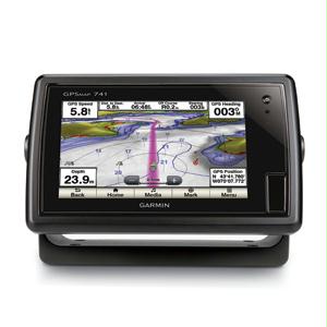
GPSMAP 741 allows for easy visibility day or night. Whether it is flat flush or gimble-mounted it will be the focal point of your helm. It has media integration and autopilot compatibility radar support and NMEA® 2000 and Wi-Fi connectivity. It includes our hallmark user-friendly interface as well as US coastal and inland mapping. With the integration of a 10Hz GPS/GLONASS receiver the 741 refreshes position and heading up to 10 times per second. It displays constant and fluid on-screen location and proves to be incredibly accurate when marking and navigating to any one of 5000 user-created waypoints. It also has Wi-Fi connectivity giving you the opportunity to connect and access marine-specific apps via smartphone or tablet.
| ||||||||||||||||||||||||||||